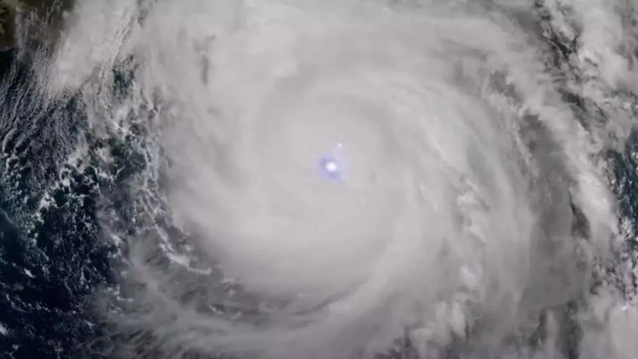
NOAA and NASA were able to track the formation of these hurricanes in real time, observing significant differences between the two storms. Image: NOAA
The National Oceanic and Atmospheric Administration (NOAA) has released the first images from its newest weather satellite, GOES-19, which features a state-of-the-art geostationary lightning mapper (GLM). This new tool, designed to monitor all forms of lightning, provided unprecedented detail during two powerful hurricanes, Helene and Milton, that hit the United States. The GLM captures both cloud-to-ground lightning and lightning contained entirely within clouds, providing crucial data for future storm predictions and safety models.
NOAA and POT They were able to track the formation of these hurricanes in real time, observing significant differences between the two storms. Hurricane Helenawhich hit six states, was captured when multiple storms merged. In contrast, Milton, a Category 5 hurricane, was distinguished by intense, continuous lightning within its eyewall as it formed. This type of detailed storm tracking could improve storm analysis and prediction models, offering a better understanding of how storms form and behave.
GOES-19, the latest in a series of Geostationary Operational Environmental Satellites (GOES), was launched on a SpaceX Falcon Heavy rocket in June and is currently undergoing post-launch testing. Once fully operational in April 2025, it will replace GOES-16 as the primary satellite monitoring severe weather in the eastern United States and the Western Hemisphere. GOES-19 will monitor various weather events, including thunderstorms, wildfires, floods, dense fog and lightning, providing more accurate data to improve weather forecasting and safety measures.
Looking ahead, NOAA and NASA are collaborating on the next generation of weather satellites, called the Geostationary Extended Observations (GeoXO) system. The GeoXO satellites, which will begin operating in the early 2030s, will feature even more advanced instruments to track not only lightning and extreme weather, but also air quality, ocean conditions, water quality, oil spills and other environmental hazards. The National Oceanic and Atmospheric Administration (NOAA) released its first images from the agency’s newest weather satellite, GOES-19, which includes the most advanced geostationary lightning mapper (GLM). The new GLM, which tracks all types of lightning, for the first time provided researchers with the level of detail of how two powerful hurricanes, Helene and Milton, hit the United States. The GLM images both cloud-to-ground lightning and lightning entirely contained within clouds, invaluable data for future storm prediction and safety modeling.
With these new images, NOAA and NASA were able to follow the development of these hurricanes in real time, marking a difference between these two storms. Hurricane Helene, which hit six states, was captured when multiple storms merged. In contrast, Milton, a Category 5 hurricane, was notable for intense, continuous lightning strikes within its eyewall as it developed. This fine-scale storm tracking can help improve storm analysis and prediction models by providing a better understanding of how storms form and act.
The newest in a long line of GOES series geostationary operational environmental satellites, GOES-19, launched last June aboard a SpaceX Falcon Heavy rocket. Currently in post-launch testing, it will be fully operational as GOES-17 in April 2025, when GOES-16 becomes the backup satellite for observing severe weather conditions in the eastern United States and the Western Hemisphere. GOES-19 would see the vast majority of these weather events, such as thunderstorms, wildfires, floods, dense fog, and lightning, where greater data accuracy improves forecasts and safety.
But how much of that information did that weather satellite capture and transmit to local bases from space to warn of all the extreme weather events like tornadoes, thunderstorms, hail and flooding, not to mention air quality, ocean conditions and of water, and oil spills? and more? NOAA and NASA are working together to launch their next generation of weather satellites called the Extended Geostationary Observations, or GeoXO system, in the early 2030s. The GeoXO satellites will have greatly improved instruments designed to track not only lightning and other weather conditions. extremes, but also air quality, ocean conditions, water quality, oil spills and more.
Disclaimer:
The information contained in this post is for general information purposes only. We make no representations or warranties of any kind, express or implied, about the completeness, accuracy, reliability, suitability or availability with respect to the website or the information, products, services, or related graphics contained on the post for any purpose.
We respect the intellectual property rights of content creators. If you are the owner of any material featured on our website and have concerns about its use, please contact us. We are committed to addressing any copyright issues promptly and will remove any material within 2 days of receiving a request from the rightful owner.